
Winter Storm Warning In Effect As Toronto, GTA Braces For Up To 40 Cm Of Snow This Weekend
Having barely just finished digging out from the snowiest storm in nearly two years, Toronto and the GTA are bracing for a third winter storm in the last eight days this weekend.
Environment Canada says that on Saturday, 10 to 15 centimetres of snow could be dumped across southern and eastern Ontario, with freezing rain possibly occurring overnight in some areas. While snowfall rates are not expected to be significant, the duration of snowfall is what will lead to increased accumulation totals.
A winter weather travel advisory is in effect for Saturday for much of southwestern Ontario including Hamilton, Burlington, Oakville and Niagara Falls. Those areas will see a mix of snow and freezing drizzle throughout the day, resulting in poor visibility at times, light ice build-up and slippery surfaces.
For Sunday, Environment Canada says a second burst of snow will arrive Sunday and bring up to another 25 centimetres of snow.
The national weather service has issued a winter storm watch for Toronto and the GTA, calling for peak snowfall rates of 3 to 6 centimetres per hour.
“Another significant winter storm is forecast to bring heavy snowfall and blowing snow to the area Sunday. Parts of the Niagara Peninsula may see a brief period of freezing rain Sunday morning,” the agency said.
The agency forecasts a total of 25 to 40 centimetres in Toronto, with similar conditions also expected in parts of southwestern Ontario.
Visibility will be somewhat difficult on Saturday evening as winds blowing out of the northeast will be around 20 to 30 km/h with steady snow falling.
However, Sunday will see heavy snow and northeasterly winds early around 30 to 40 km/h and gusts to 70 at times. By the afternoon, those winds change to the northwest and still remain very strong. Visibility will be near zero tomorrow throughout much of the day.
The TTC is preparing its rail yards, garages, and critical infrastructure while implementing its storm mitigation plans to keep the service running as scheduled. The transit agency says there are no scheduled subway closures this weekend and is encouraging motorists to stay off the roads and take transit to get around the city.
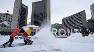
Crews in Toronto are still clearing roads and sidewalks after the city experienced its highest single-day snowfall total since March 2023.
Toronto officials say they have ticketed 1,500 vehicles and towed 10 others parked illegally along snow removal routes.
As the low-pressure system exits the province by Monday morning, it’s expected to usher in colder air from the northwest and bring localized lake-effect snow squalls southeast of Georgian Bay.