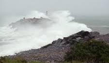
Tens of thousands of hydro customers remain without power as Lee, now a strong post-tropical storm, begins moving out of the Maritimes into the Gulf of St. Lawrence.
Environment Canada says Lee will move out of western Prince Edward Island early this morning and head across the Gulf of St. Lawrence, passing west of the Magdalen Islands mid-morning and reaching northern Newfoundland in the evening.
The weather agency says conditions are beginning to improve in many areas of Nova Scotia and southern New Brunswick, but the region will continue to experience rain, strong winds, and high waves along the Atlantic coast throughout the day.
Tropical storm warnings are in effect for Kings County, Prince Edward Island, the Magdalen Islands, and Antigonish County, Cape Breton Island, Guysborough County, and Halifax County, east of Porters Lake in Nova Scotia. However, those warnings have ended for Queens County, Prince Edward Island, and Pictou County and Halifax Metro – Halifax County West in Nova Scotia.
As Lee continues to weaken, conditions in most areas to the south and east of the storm are expected to improve through the morning.
Most of New Brunswick, Gaspesie, and Anticosti Island are continuing to experience heavy rain, which will move into the Lower Quebec North Shore today. More than 100 millimetres of rain has been reported at Grand Manan Island and Gaspe.
Wind gusts reaching 90 kilometres an hour are still being reported along the eastern shore of Nova Scotia, although high winds are expected to greatly diminish by noon Sunday.
As of 8:00 a.m. ADT, Nova Scotia Power was reporting outages affecting more than 104,000 customers, 12,854 NB Power customers were in the dark and almost 300 Maritime Electric customers were without power in P.E.I.
The latest update from Environment Canada put the storm about 23 kilometres northwest of Summerside, P.E.I, moving northeast at 30 kilometres per hour with maximum sustained winds of 83 kilometres per hour.


